Restrictions on planning
According to Ly Khanh Tam Thao, acting head of Technical Infrastructure Office at the city Department of Planning and Architecture, the city development has been based on the master plan approved by the Prime Minister in 2010. However, the city authority intends to adjust the master plan, making the Department of Planning and Architecture in charge of carrying out initial research for the adjustment of planning.
There are three main reasons for planning adjustments. Firstly, Ho Chi Minh City is located in “Ho Chi Minh City area” which combines eight provinces and cities. In December 2017, the Prime Minister approved the planning of “Ho Chi Minh City area” until 2030 with a vision lasting until 2050. So, it is necessary to change the planning of the city to suit the general direction of the whole region. Also, the adjustment must adapt to climate change of the area as well as sea level rise. Lastly, after nearly a decade, the master plan should be adjusted to suit the practical requirements of a city.
Vice Chairman of HCM City People's Committee, Tran Vinh Tuyen, pointed out that the biggest problem of the city is its planning. “In three steps of planning: setting up a plan, plan management and plan operation, we all see limitations,” he said. Now the planning is only a subjective desire of state agencies, it is not an investment opportunity of enterprises or a demand of the citizens, he continued. Many policies haven’t worked well for it either. The planning progress is also causing many troubles, affecting the legitimate interests of the people. He hoped this renovated planning will become an opportunity for all investors and meet the desire of the people.

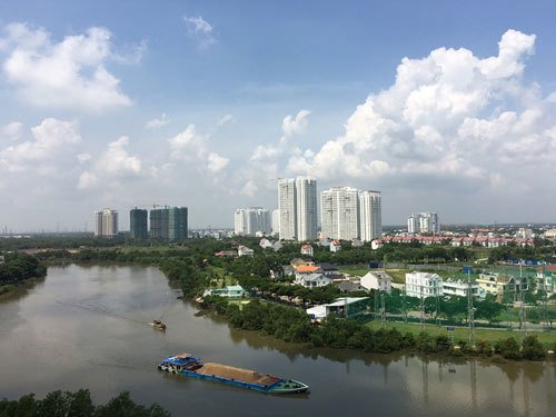
Urban development in the south of HCM City faces a challenge due to climate change
Redirecting the development
Thao said that the direction of the city development is one of the main points that needs researching. Previously, the city focused on developing in the East and the South, but it must shift elsewhere. “In this adjustment, we need to consider the connection with the economic zones in the neighboring provinces as well as the geological and hydrographical conditions of the city in accordance with climate change.” He suggested to focus on the northwestern region because its land is high and has many good conditions for urban development.
He also noted that the structure of land and urban area should be changed to be used more effectively. The existing center will be renovated giving priority to the development of public transport, population regulation and distribution of population and housing. To adapt to climate change, it’s necessary to combine urban development and flood risk management.
Meanwhile, Tuyen said the socio-economic development should be planned before the urban planning. That means commercial services, high-tech industry and tourism will be developed first, and the new lands will be built in accordance with the above orientation.
He added that the adjustment should solve the problems caused by climate change. High building projects in Nha Be and Can Gio districts will impact the areas erosion and landslides. Therefore, development in the North-West direction is an urgent requirement.
Vietnam is one of the countries severely affected by climate change and its related disasters. The Mekong Delta is one of the most susceptible and vulnerable deltas in the world to sea level rise. HCM City has 40 erosion-prone areas in several districts, mostly located in the south of the city. Change in planning is a must in order to continue development in a safe and smart way.


